- Product Details
- {{item.text}}
Quick Details
Quick Details
-
Place of Origin:
-
Guangdong, China
-
Brand Name:
-
ONWA
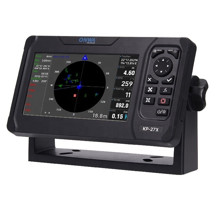
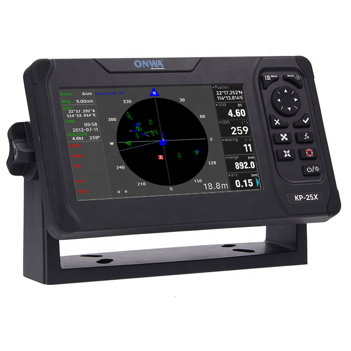
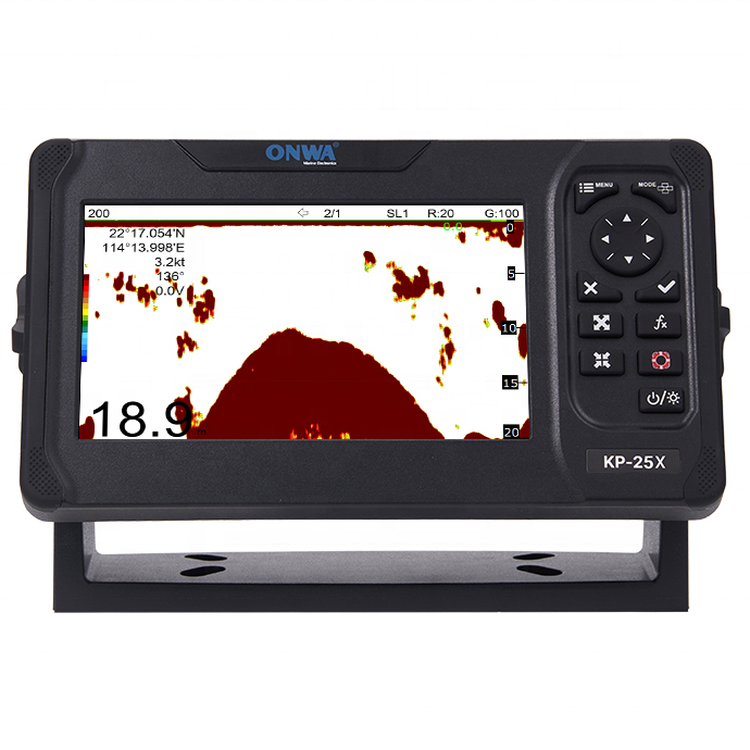
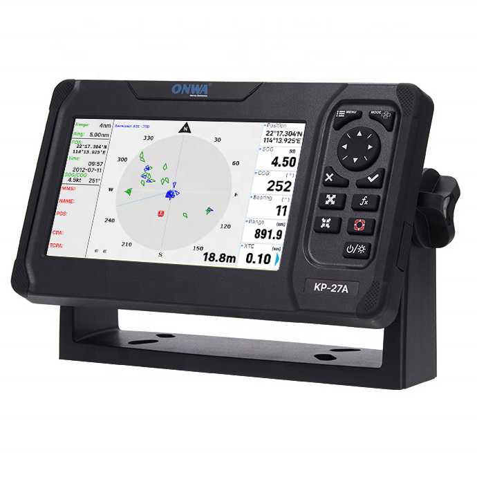
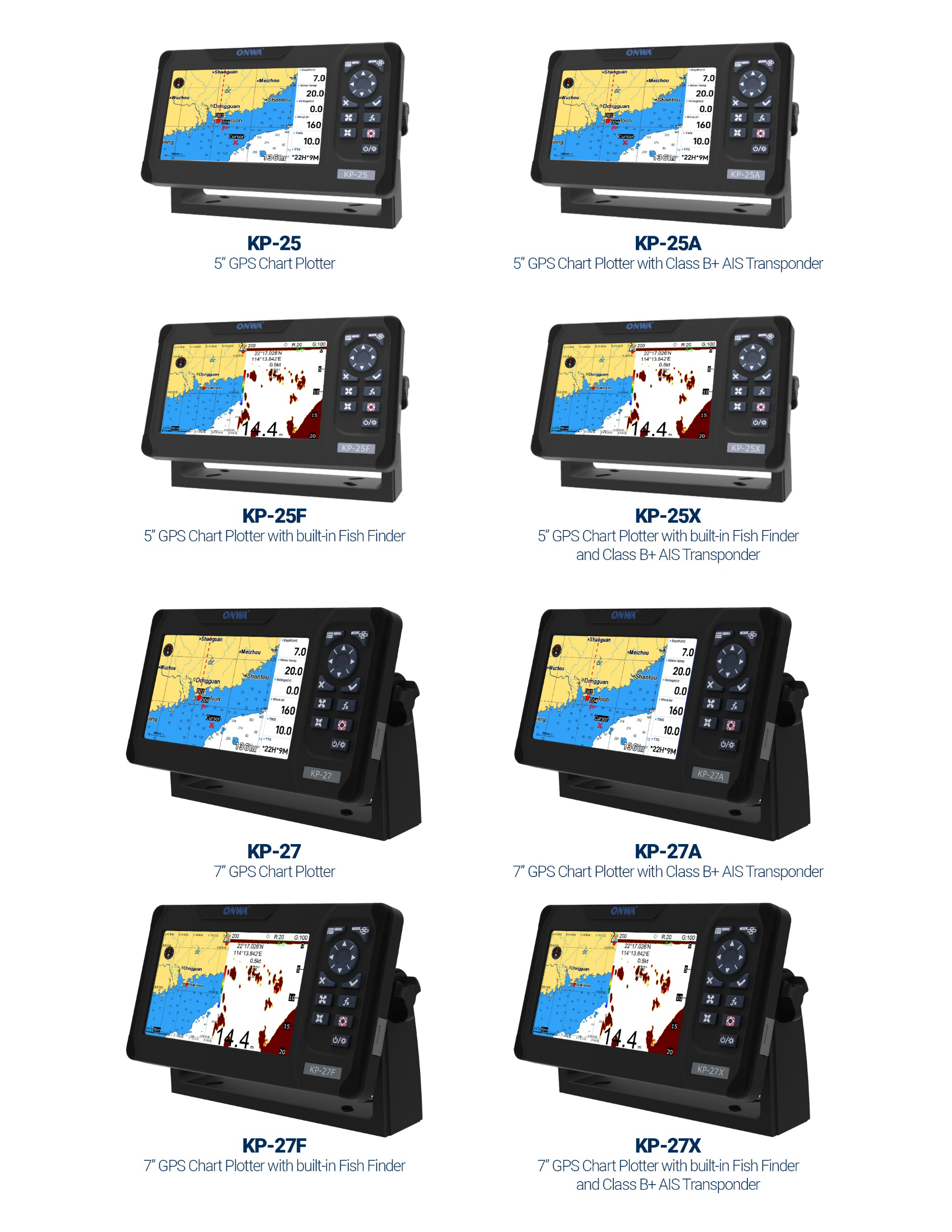
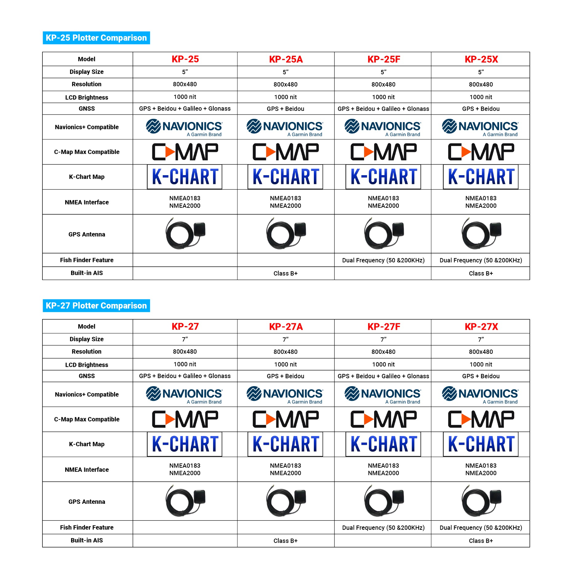
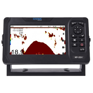
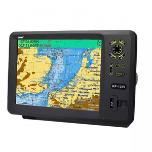
ONWA KP-25 / KP-27 series GPS chart Plotter with built-in Fish Finder and Class B+ AIS transponder
Specifications
Plotter Characteristics
Waypoints/icons
12,000 user waypoints with name, symbol,
3 system waypoints: MOB,Start,cursor
10 proximity waypoints
3 system waypoints: MOB,Start,cursor
10 proximity waypoints
Routes
30 routes waypoint up to 170 points each,
plus MOB and Track Navigation or Goto Track modes
plus MOB and Track Navigation or Goto Track modes
Tracks
16,000 points automatic track log;
10 saved tracks (up to 16,000 track points each)
lets you retrace your path in both directions
10 saved tracks (up to 16,000 track points each)
lets you retrace your path in both directions
Alarms
XTE, Anchor drag, arrival, speed, voltage, proximity waypoint,
Timer and AIS (CPA and TCPA) alarm
Timer and AIS (CPA and TCPA) alarm
Drawing
1000 Drawing Marks; 2000 Drawing Lines (40 points each);
1000 Drawing Place Name; 8 colors for Drawing
1000 Drawing Place Name; 8 colors for Drawing
Pallete
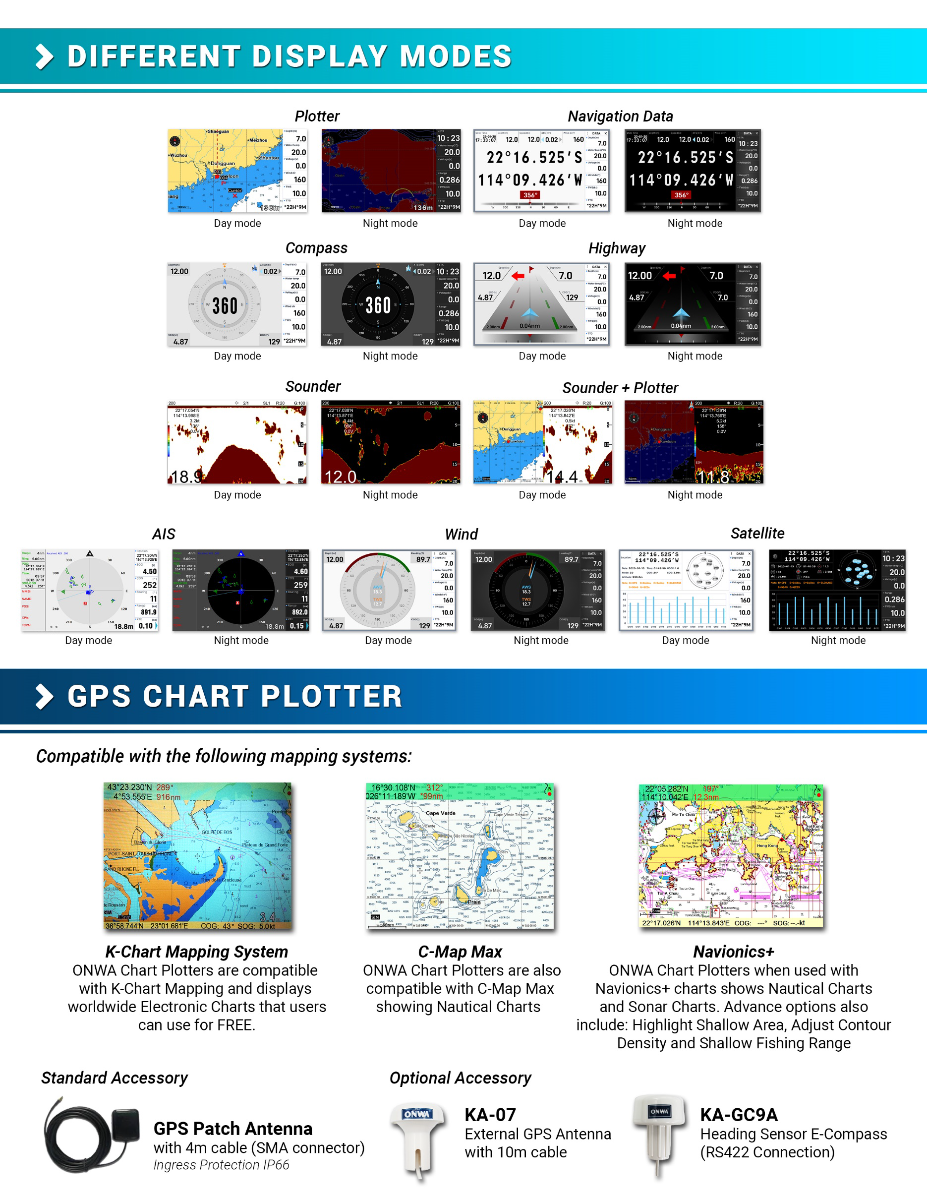
Normal
Daylight exposed to sunlight
Night in dark environment
NOAA paperchart colors
Daylight exposed to sunlight
Night in dark environment
NOAA paperchart colors
Tides
Built-in Worldwide Tide Data
Position Format
Lat/Lon
Basemap
Worldwide
External Map
Compatible with K-Chart 2.0, K-Chart 3.0, C-Map Max and Navionics+
User Data Storage
Internal backup of user settings or external SD-card
Plot Interval
5secs to 60 mins or 0.01 to 10nm
Plotting Scales
0.001 to 700nm
AIS
700 targets display
AIS Target Tracking
10 Manually saved tracks (300 points each)
AIS Messaging
ONWA AIS to ONWA AIS
Perspective view
On/off (available for C-Map only)
Celestial
Sunrise/Sunset Moonrise/Moonset
GPS Receiver Characteristics
Receiver
50 parallel channel GNSS receiver continuously tracks and
uses up to 50 satellites to compute and update your position
uses up to 50 satellites to compute and update your position
Acquisition time
Cold start: 29 seconds
Hot start: 1 second
Hot start: 1 second
Update rate
1 second
Accuracy
Position:3 meters(95%) without S/A
Velocity: 0.1 meter/sec without S/A
Velocity: 0.1 meter/sec without S/A
SBAS
Supported
GNSS
GPS+ Beidou+ Galileo+ Glonass
Dynamics
Altitude: 18,000 m
Velocity: 515 m/s
Velocity: 515 m/s
Datum
WGS 84 & user defined
Antenna
GPS Patch Antenna
GPS Interface (NMEA0183)
GPS Data
RS422 input/output, NMEA 0183 V3.01 and V4.11
GPS Input Baudrate
Auto Scan (4800, 9600, 19200 and 38400)
GPS Output Baudrate
Selectable among 4800, 9600, 19200 and 38400
AIS Interface (NMEA1083)
AIS Data
RS232 output VDO, VDM, GGA, GSA, GSV and RMC
AIS Output Baudrate
38,400
Echo Sounder Characteristics
Echo Color
16 colors (including background color) according to echo intensity. The background color is selectable from blue, light blue, white and black
Basic Range
Meters 5/10/20/40/80/150/200/300/600/1000
Feet 15/30/60/120/200/400/600/1000/2000/3000
Fathoms 3/5/10/20/40/80/150/300/600
*The basic ranges can be changed on the system menu.
Feet 15/30/60/120/200/400/600/1000/2000/3000
Fathoms 3/5/10/20/40/80/150/300/600
*The basic ranges can be changed on the system menu.
Range Shift
Up to 1000 meters (3000 feet,600 fathoms)
Zoom Range
Times 2,3,4 and 6 ranges
Bottom Lock Expansion Range
5/10 meters,10/20 feet,2/5 fathoms
Auto Mode
Automatic adjustment of range and gain
Display Mode
High Frequency (200K),Low Frequency (50K), Dual (200K and 50K 1/2 display on each),
Zoom (200K and 50K zoom) and A-scope Display
Zoom (200K and 50K zoom) and A-scope Display
Zoom Display
Marker Zoom, Bottom Zoom and Bottom-lock Expansion
Display Advance Speed
Lines/TX:Freeze, 1/8, 1/4, 1/2, 1/1, 2/1, 4/1, 6/1,8/1 and 10/1
TX Frequency
50 and 200kHz (alternately transmitted)
Power Output
600W
Pulse-length/TX rate
| Display End Depth (m) |
5
|
10
|
20
|
40
|
80
|
150
|
200
|
300
|
600
|
1000
|
| Pulse-Length 200K(µs) |
120
|
220
|
320
|
520
|
920
|
1020
|
1020
|
1020
|
1020
|
1020
|
| Pulse-Length 50K(µs) |
170
|
270
|
370
|
570
|
970
|
1070
|
1070
|
1070
|
1070
|
1070
|
| TX Rate(pulse/min) |
2000
|
1333
|
706
|
353
|
171
|
98
|
75
|
53
|
38
|
27
|
| TX period(millisecond) |
30
|
45
|
85
|
170
|
350
|
610
|
800
|
1120
|
1580
|
2200
|
Interference Rejecter
Rejects unwanted signals by comparing last and present echoes in strength.
Alarm
Fish and Bottom alarms,
Temperature alarm (sensor required)
Temperature alarm (sensor required)
NMEA0183 Sentence Supported
INPUT
(Auto scan Baudrate)
GGA, GLL, GSA, GSV, RMC, HDG, HDM, HDT
VTG, ZDA, MTW, VWR, VWT, MWD, VPW, VHW
TLL, TTM, VDO, VDM, GNS, MTA
RMA, DBT, DPT, MWV, BWC, XTE, ZDL, WPL, AAM,
APB, BOD, RMB, DSC, MDA, RPM, XDR
GGA, GLL, GSA, GSV, RMC, HDG, HDM, HDT
VTG, ZDA, MTW, VWR, VWT, MWD, VPW, VHW
TLL, TTM, VDO, VDM, GNS, MTA
RMA, DBT, DPT, MWV, BWC, XTE, ZDL, WPL, AAM,
APB, BOD, RMB, DSC, MDA, RPM, XDR
OUTPUT
Baudrate: Selectable 4800, 9600, 19200, 38400
GGA, GLL, RMC, GSA, GSV, AAM, APA
APB, BOD, BWC, BWR, DBT, DPT, HDT
MTW, RMB, TLL, VTG, WPL, XTE, ZDA
ZTG, ZDL, MWD, VPW, VWR, VWT
GGA, GLL, RMC, GSA, GSV, AAM, APA
APB, BOD, BWC, BWR, DBT, DPT, HDT
MTW, RMB, TLL, VTG, WPL, XTE, ZDA
ZTG, ZDL, MWD, VPW, VWR, VWT
OUTPUT for Autopilot
APA, APB, BOD, XTE
Power Supply
10.5 to 34VDC, current drain <1.0A at 12V
PHYSICAL
Size
143.1mm(H)X215.3mm(W)X63.1mm(D)
Weight
1.0 kg
Display
5-inch Color TFT dayview LCD, 800×480 pixels
Waterproofing
Display unit (Front Panel): IP66
Antenna unit: IP66
Antenna unit: IP66
Temperature range
Display unit: -15℃ to +55℃
Antenna unit: -25℃ to +70℃
Antenna unit: -25℃ to +70℃
Equipment List
Display unit
Quick manual
GPS Patch Antenna with 4m cable (SMA connector)
Mounting Brackets
Standard accessories pack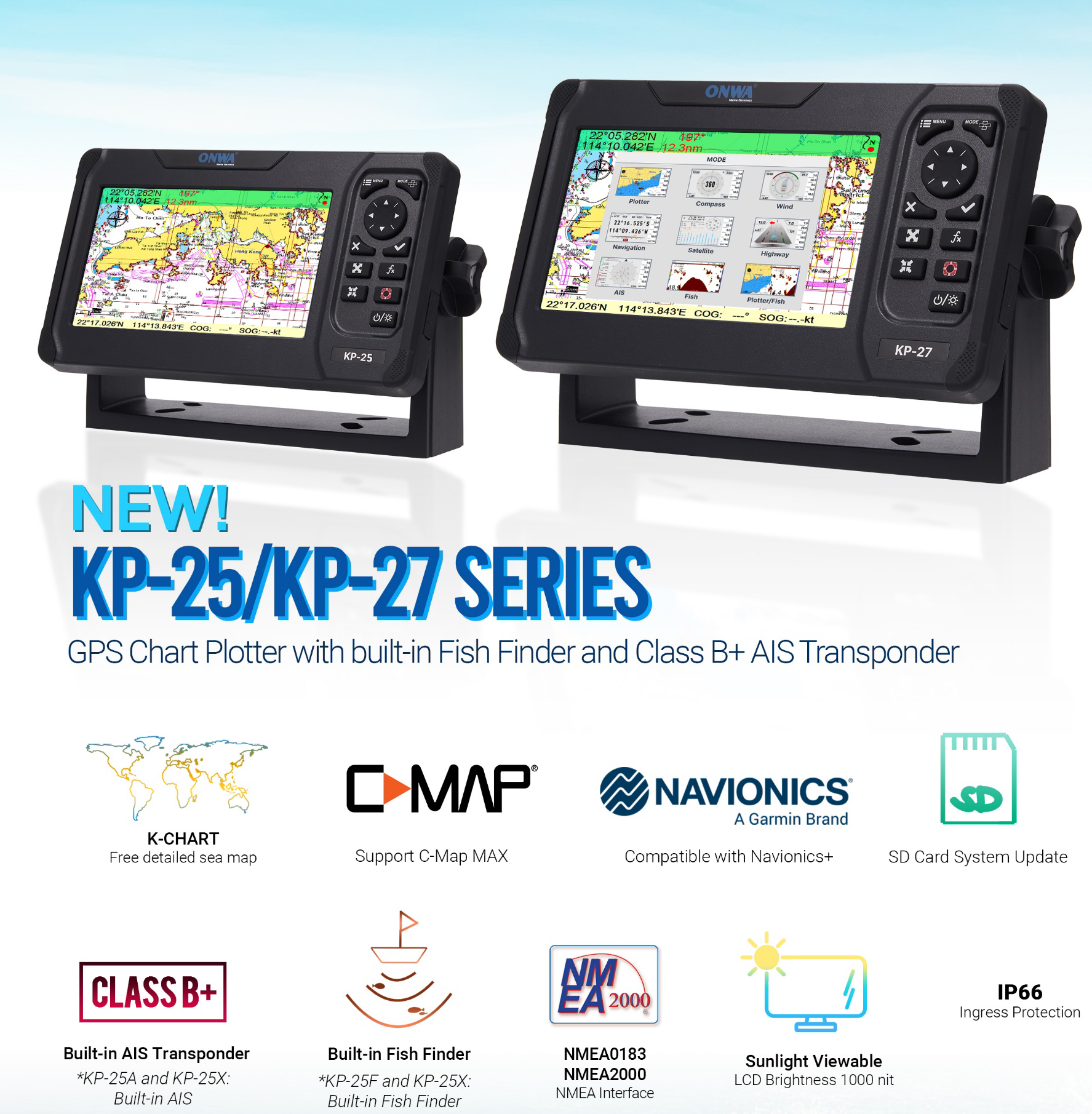
Quick manual
GPS Patch Antenna with 4m cable (SMA connector)
Mounting Brackets
Standard accessories pack
Hot Searches
