- Product Details
- {{item.text}}
Quick Details
-
Application:
-
Earthquake Monitoring
-
Frequency:
-
5Hz
-
Measurement range:
-
0.1-1600Hz
-
Weight:
-
2.2KG
-
Function:
-
4G Remote Transmission
-
Temperature range:
-
-40℃-85℃
-
GPS:
-
L1 C/A
-
BEIDOU:
-
B1I
-
GLONASS:
-
Simultaneous L1
Quick Details
-
Place of Origin:
-
Anhui, China
-
Brand Name:
-
Guowei
-
Product name:
-
UGL-3C
-
Application:
-
Earthquake Monitoring
-
Frequency:
-
5Hz
-
Measurement range:
-
0.1-1600Hz
-
Weight:
-
2.2KG
-
Function:
-
4G Remote Transmission
-
Temperature range:
-
-40℃-85℃
-
GPS:
-
L1 C/A
-
BEIDOU:
-
B1I
-
GLONASS:
-
Simultaneous L1
PRODUCT SPECIFICATIONS
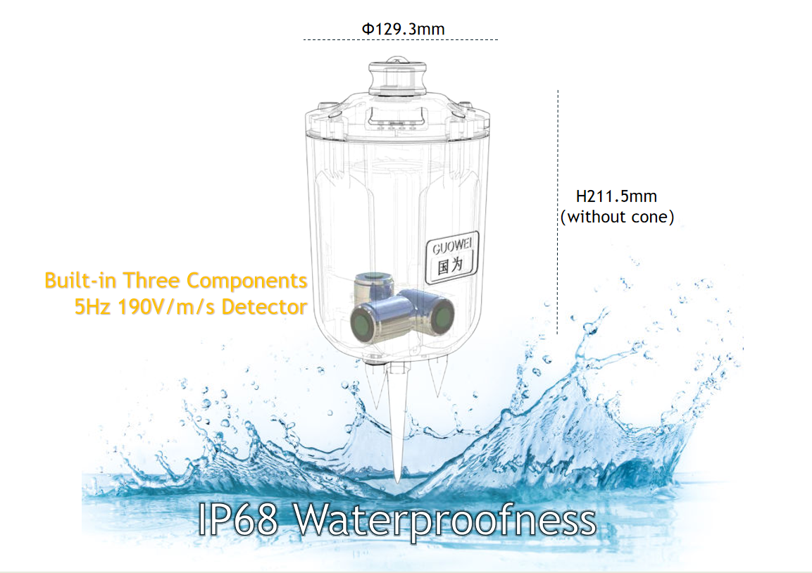
The advantages of UGL-3C are high-sensitivity three-component, 4G remote real-time transmission, built-in 25-day ultra-long field continuous operation, and external power supply that can last for 120 days. It can truly realize real-time intelligent monitoring of micro seismic events and is also suitable for seismic background noise imaging.
The detection system consists of two parts: hardware and software.
Hardware
includes: collection station, external battery pack, and portable integrated box. The number of collection stations is configured according to actual deployment requirements. When the application scenario is long-term monitoring in the field, an external battery pack is required, which can achieve continuous operation for 120 days. The portable all-in-one box enables 6 channels of simultaneous charging and data recovery.
Software
includes: real-time monitoring software, data recovery software and data conversion software. Real-time monitoring software is used during equipment deployment, through 4G remote real-time transmission, remote intelligent configuration of operation parameters, real-time monitoring of instrument status and map display of instrument location, data quality monitoring and other functions; data recovery software is used for node equipment to download data, downloaded data The file is in EQD format. After downloading, you can use data conversion software to view and convert it. The main function of the data conversion software is to convert EQD data into the required target data format according to different operating methods. At the same time, it can view and analyze the waveform of the original EQD data and the converted output data. It supports SEG-2 and SEG-Y. , SEG-D, SAC, Mini-SEED and other data formats.

|
Sensor
Specifications
|
Item
|
Data
|
|
|
||||
|
Natural Frequency
|
Power
|
5Hz
|
|
|
||||
|
Frequency Bandwidth
|
|
0.2Hz~200Hz
|
|
|
||||
|
Sensitivity
|
Bucket capacity
|
190 V/m/s
|
|
|
||||
|
Frequency Response
|
Operating weight
|
0.1~1600Hz
|
|
|
||||
|
Distortion
|
|
<0.1% @12Hz, (0° ~ 10°) tilt,(0°~3°) horizontal tilt
|
|
|
||||
|
Physical Indicators
|
Item
|
Data
|
|
|
||||
|
Size
|
Power
|
Φ129.3mm,H211.5 mm
|
|
|
||||
|
Weight
|
Bucket capacity
|
<2.2kg(with battery without cone)
|
|
|
||||
|
Waterproof
|
|
IP67
|
|
|
||||
|
Operation Temperature
|
Operating weight
|
-40℃~85℃
|
|
|
||||
|
Self-noise Level
|
|
Whole frequency band lower than the NHNM curve,5s~1Hz lower than the NLNM curve
|
|
|
||||

|
Electronics Indicators
|
Item
|
Data
|
|
|
||||
|
Channels
|
Power
|
3-Channels (built-in three-component sensor)
|
|
|
||||
|
Endurance
|
|
Built in battery, typical working conditions, with a range of 20 days (4G transmission mode). External battery can achieve
year-round non-stop and ultra long battery life |
|
|
||||
|
Synchronization Accuracy
|
|
≤1 µs(After GPS signal lock)
|
|
|
||||
|
AD Converter
|
|
32Bit ADC
|
|
|
||||
|
Preamplifier Gain
|
|
0dB,6dB,12dB,18dB,24dB,30dB,36dB
|
|
|
||||
|
Sampling Interval
|
|
4ms,2ms,1ms,0.5ms,0.25ms
|
|
|
||||
|
Maximum Input
|
|
5 V
|
|
|
||||
|
Dynamic Range
|
|
123dB(1ms Sampling Interval,0dB Preamplifier Gain)
|
|
|
||||
|
Noise Level
|
|
0.11μV RMS(1ms Sampling Interval,36dB Preamplifier Gain)
|
|
|
||||
|
Common-mode Rejection
|
Bucket capacity
|
>110dB(1ms Sampling Interval,0dB Preamplifier Gain)
|
|
|
||||
|
Harmonic Distortion
|
Operating weight
|
<-122dB(1ms Sampling Interval,0dB Preamplifier Gain)
|
|
|
||||


|
Charging and Data Recovery Cabinet
|
Item
|
Data
|
|
|
||||
|
Number of Channels
|
Power
|
6 Channels(Charging and data recovery at same time)
|
|
|
||||
|
Weight
|
|
4.7 kg
|
|
|
||||
|
Size
|
|
360mm*280mm*180mm
|
|
|
||||
|
Data Transmission Interface
|
|
RJ45 Ethernet
|
|
|
||||
|
Charging Current
|
|
Single Channel Max 4A, 16 Channels Max 58A
|
|
|
||||
|
Input Power
|
|
220V/110V AC, Max Current 5A, Max Power 1100W
|
|
|
||||
Practical Application for UGL-3C:
Urban und erground space, roadbed boulders, urban drainage pipelines, detection of engineering crack.
Foundation or subgrade survey for hollowing Division of rock formation and cover layer Rock formation division and disease
Geological body survey Re
search on the embedded depth, shape and distribution rule of the basal layer
2.Resources exploration:
Lithology mutation (aquifer), coal and oil and gas exploration, etc.
Lithology mutation (aquifer), coal and oil and gas exploration, etc.
Real time monitoring and warning of oil and gas fracturing, landslides, and road collapses.
Real time monitoring and imaging of oil and gas pressure cracking, CCUS carbon dioxide storage;
3.Structural exploration:
Karst, fault fracture zone, collapse column, goaf, real-time monitoring of overburden thickness.
Karst, fault fracture zone, collapse column, goaf, real-time monitoring of overburden thickness.
4.Real time monitoring:
Mobile real-time monitoring station of seismic bureau system;
Long term real-time monitoring of various micro seismic events;
Real time monitoring and warning of geological disasters, landslides, collapses, etc;
Research on real-time monitoring of micro earthquakes and real-time imaging of background noise
in universities and research institutes.
Long term real-time monitoring of various micro seismic events;
Real time monitoring and warning of geological disasters, landslides, collapses, etc;
Research on real-time monitoring of micro earthquakes and real-time imaging of background noise
in universities and research institutes.
5.Natural activities:
Monitoring of crustal and upper mantle plate activity.
Monitoring of crustal and upper mantle plate activity.
Dense array, background noise imaging, geothermal energy,active faults, real-time monitoring of strategic mineral
exploration, scientific research and seismological research.
exploration, scientific research and seismological research.
4G Real-time Remote Monitoring
1. Real time monitoring based on 4G/5G, real-time intelligent processing and generation of velocity profiles
2. Ultra low power consumption, same battery, longer field acquisition time
3. Standard industrial design, production, and inspection testing
4. Full series without physical switches, lightweight and durable, with higher reliability in the wild
5. Abnormal displacement, vibration, intelligent alarm and anti-theft
3D Processing Software
Short period dense array passive source detection
In the past ten years, with the development and improvement of portable integrated short-period seismometers, short-period dense array passive source detection technology has gradually become an important means of detecting the fine structure of the earth.
This technology uses natural source seismic signals, environmental noise or other force sources that can be recorded by seismometers (such as high-speed rail vibration) as signal sources, and uses densely arranged short-period seismometers to carry out seismic observations.
Hot Searches


