- Product Details
- {{item.text}}
Quick Details
-
Working frequency:
-
410-470MHz
-
Full Satellite support::
-
GPS, BDS, GLONASS, SBAS, Galileo
-
management platform:
-
WebUI
-
Tilt survey and Electronic bubble:
-
yes
-
Wireless data communications:
-
Wi-Fi Bluetoth 4.0 NFC: Quick Bluetoth pair
-
Software:
-
EGStar/SurvCE(option)/FieldGenius(option)
-
iVoice:
-
support
-
Size:
-
12.9cm * 11.2cm
-
Weight:
-
1.1 KG
Quick Details
-
Place of Origin:
-
China
-
Brand Name:
-
South
-
Channels:
-
220
-
Working frequency:
-
410-470MHz
-
Full Satellite support::
-
GPS, BDS, GLONASS, SBAS, Galileo
-
management platform:
-
WebUI
-
Tilt survey and Electronic bubble:
-
yes
-
Wireless data communications:
-
Wi-Fi Bluetoth 4.0 NFC: Quick Bluetoth pair
-
Software:
-
EGStar/SurvCE(option)/FieldGenius(option)
-
iVoice:
-
support
-
Size:
-
12.9cm * 11.2cm
-
Weight:
-
1.1 KG
G1 GNSS RTK Receiver GPS Land Surveying Instrument

Description
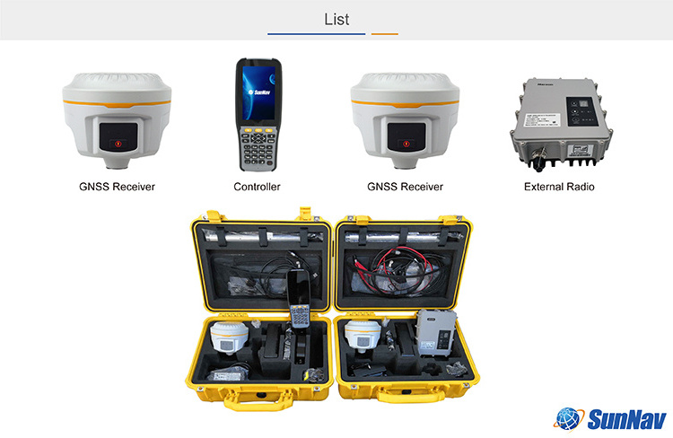
SunNav G1 Plus, new generation integrated RTK system with smaller size and innovative design.New generation of embedded Linux operating system platform improves RTK performance and work efficiency, leads the direction of new generation RTK with excellent performance, provides high-efficiency and intelligent surveying experience to customers. It isn’t simply smaller, it does better in everywhere.
Features
• Full Satellite support: GPS, BDS, GLONASS, SBAS, Galileo
• Intelligent Platform:
Linux OS
WebUI management platform
Cloud service: 24 hours Cloud service: online update software, online register, Remote diagnosis and operate
for the users.
• Tilt survey and Electronic bubble
• Wireless data communications:
Wi-Fi
Bluetoooth 4.0
NFC: Quick Bluetoooth pair
• Data Link:
Built-in functional digital radio
Built-in network module: support 4G/3G modules.
• iVoice
• Software: EGStar/SurvCE(option)/FieldGenius(option)


Engineering Star3.0 surveying software is the graphic software with simpleness, high efficiency and strong function.
It provides the most usual function, such as detailing, stake-out point and stake-out line, with engineering and graphic interface.
It also has the added function of stake-out curved line, and stake-out road .
Not only does it use the characteristics of international comparable software for reference, such as convenient graphic display and precise structural module, it also combines the concrete specialty of the domestic fieldwork, making engineering star in the wake of international fashion and meet the needs of fieldwork as well.
Engineering Star3.0 also has many other features, such as flexible zoom graphic interface, tabular menu, which directly display critical task on the screen, abundant characteristics of fieldwork, complete edition, standard industrialized data output, coordinate collection, comprehensive RTK vector, GPS original and other data format.

| Surveying performance | Channels :220 Channels |
|
Sigmal Tracking
-BDS B1,B2,B3 -GPS L1C/A,L1C,L2C,L2E,L5 -GLONASS L1C/A,L1P,L2C/A,L2P,L3 -SBAS L1C/A.L5(Just for the satellites supporting L5) -Galileo GIOVE-A, GIOVE-B,E1,E5A,E5B -QZSS,WAAS,MSAS,EGNOS,GAGAN,SBAS |
|
|
GNSS Features
-Positioning out rate:1Hz~50Hz -Initialization time : <10s -initialization reliability:>99.99% |
|
| Positioning Precision |
Code Differential GNSS Positioning
Horizontal: 2.5mm+1ppm RMS Vertical : 5mm+1ppm RMS SBAS positioning accuracy: typically <5m 3DRMS RMS Static GNSS Surveying Horizontal: 2.5mm+0.5ppm RMS Vertical : 5mm+0.5ppm RMS Real-Time Kinematic Surveying Horizontal: 8mm+1ppm RMS(Baseline<30km) Vertical : 15mm+1ppm RMS Horizontal: 8mm+0.5ppm RMSNetwork RTK Vertical : 15mm+0.5ppm RMS RTK initiallzation time:2~8s |
|
Physical
Dimension:12.9cm*11.2cm Weight:≤1kg Material:Magnesium aluminum alloy shell |
|
|
Environmental
Operating: -45℃~60℃ Storage: -55℃~85℃ Humidity:Non-condensing Waterproof/ Dustproof IP67 standard, protect from temporary immersion to depth of 1m IP67 standard, protect from dust Shock and Vibration Withstand 2 meters pole drop onto the cement ground naturally Withstand 40G 10 milliseconds sawtooth wave impact test |
|
| Electrical |
Power Consumption:1.8W
Battery:Single battery capacity 3400mAH ,standard two batteries Battery Life |
|
Single battery
7h(static mode) 5h(intermal UHF base mode) 6h(rover mode) |
|
| Communications and Data Storage |
I/O Port
5PIN LEMO external power port +RS232 7 PIN LEMO RS232 +USB 1 network/radio data link antenna port SIM card slot |
|
Wireless Modem
Integrated internal radio receiver and transmitter 0.5W/2W External radio transmitter 35W Working frequency: 410-470MHz Communication protocol: Trim Talk450s,TrimMark3,SOUTH(KOLIDA),PCC EOT Cellular Mobile Network: WCDMA3.5G network communication module,GPRS/EDGE compatible,4G,CDMA2000/EVDO 3Goptional Double Module Bluetoooth: Realizing close range (shorter than10cm) auto,atic pair between G1 plus and controller (controller equipped with NFC wireless communication module ) |
|
|
Data Storage/Transmission
4GB intemal storage, more than 3 years raw observation data (about 1.4M/day, based on recording from 14 satellites) Plug and play mode of USB data transmission |
|
|
Data Format
Differential data format: CMR+,CMRx,RTCM2.1,RTCM2.3,RTCM3.0,RTCM3.1,RTCM3.2 GPS output data format: NMEA 0183,PJK plane coordinates,binary code,Trimble GSOF Network model support: VRS, FKP, MAC, supporting NTRIPprotocol |


