- Product Details
- {{item.text}}
Quick Details
-
channel:
-
496 Channels
-
GPS:
-
L1,L2C,L2P,L5
-
GLONASS:
-
L1,L2
-
BDS:
-
B1,B2,B3,B1C,B2A
-
GALILEO:
-
E1C E5A E5B
-
SBAS:
-
support
-
RTK accuracy:
-
Horizontal:+-(8mm+1*10-6D) Vertical:+-(15mm+1*10-6D)
-
Static accuracy:
-
Horizontal:+-(2.5mm+0.5*10-6D)Vertical:+-(5mm+0.5*10-6D)
-
Protocol:
-
TrimTalk450S,TrimMark3, SOUTH, CHC,SATEL,HI-TARGET
-
Battery:
-
High capacity built-in battery 6800mAh 7.4V
Quick Details
-
Warranty:
-
1 year
-
Place of Origin:
-
Tianjin, China
-
Brand Name:
-
Tianyu
-
channel:
-
496 Channels
-
GPS:
-
L1,L2C,L2P,L5
-
GLONASS:
-
L1,L2
-
BDS:
-
B1,B2,B3,B1C,B2A
-
GALILEO:
-
E1C E5A E5B
-
SBAS:
-
support
-
RTK accuracy:
-
Horizontal:+-(8mm+1*10-6D) Vertical:+-(15mm+1*10-6D)
-
Static accuracy:
-
Horizontal:+-(2.5mm+0.5*10-6D)Vertical:+-(5mm+0.5*10-6D)
-
Protocol:
-
TrimTalk450S,TrimMark3, SOUTH, CHC,SATEL,HI-TARGET
-
Battery:
-
High capacity built-in battery 6800mAh 7.4V
SunNav TIANYU C6 GNSS RTK Receiver
Multi Frequency GNSS receiver
SunNav gps rtk dual frequey geophysical survey equipment Cheap gnss receiver
G970II rtk gps
same with Foif A90 Stonex S900 chc x91 gps rtk CHC i80 chc i90 GPS RTK receiver

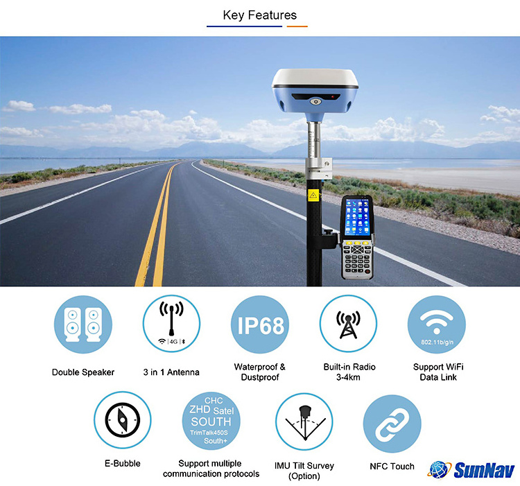
2.Built-in TX/RX radio,410-470 Mhz, Support multiple protocols: SOUTH, TrimTalk450S, Satel, ZHD, CHC(huace), etc
3.NFC touch: auto paired with the receiver
4.Electronic bubble function
5.8GB solid state storage, supporting 32GB external extension
6.IMU Tilt survey function, (optional)
7.WebUI: Built-in WebUI management background
8.plug-and-play USB data transmission; HTTP data download
9.Cloud Service: remotely manage and configure devices
10.Intelligent voice: double speaker design, three-dimensional sound broadcast
11.GNSS antenna, Bluetooth antenna, WIFI antenna "three-dimensional one" highly integrated design
12.Waterproof and dustproof design, IP68 protection level.


Carlson SurvCE/FieldGenius/esurvey
Surpad Software
Professional,intuitive and efficient
This
Surpad
RTK data controller Field Software is designed & developped by the most professional software R&D engineers team, which brings you a professional, intuitive and efficient measurement of the new experience. The
Surpad
software integrates construction survey, power survey, GIS data collecting in one unit. This software is compatible both with Windows Mobile and Android platform, it also supports the smart phone to be used as data controller.
1.
Power Survey
Line selection, cross measurement, 4-D Data Format output.
2.
Road survey
Road design, Middle Side Stake Layout, Cross section survey.
3.
Base Map Loading
Support vector data loading such as DXF, SHP and GCP.
4.
GIS collection
Support Attribute Data Collecting by Self-Defined data dictionary and export GIS exchange format.
5.
Post Processing Software GGO
Support to convert the data format into RINEX, which is compatible with AutoCAD and other Drawing & Mapping Software.
| Items | Specification | |
| GNSS | Signal Tracking | 496 Channels |
| BDS:B1,B2,B3,B1C,B2A | ||
| GPS: L1,L2C,L2P,L5 | ||
| GLONASS: L1,L2 | ||
| Galileo: E1C,E5A,E5B | ||
| SBAS,QZSS: support | ||
| L-Band :support | ||
| GNSS Features | Positioning output rate 1Hz~20Hz | |
| Initialization time : <10s | ||
| Initialization reliability : >99.99% | ||
| All-Constellation receiving Technology that supports all existing and planned GNSS constellation signals | ||
| Positioning Precision | Code Differential GNSS Positioning | Horizontal:0.25 m + 1 ppm RMS |
| Vertical:0.50 m + 1 ppm RMS | ||
| SBAS positioning accuracy: typically <5m 3DRMS | ||
| Static GNSS Surveying | Horizontal:±(2.5mm+0.5×10⁻⁶D) | |
| Vertical:±(5mm+0.5×10⁻⁶D) | ||
| RTK Surveying | Horizontal:±(8mm+1×10⁻⁶D) | |
| Vertical:±(15mm+1×10⁻⁶D) | ||
| Operating system / user interaction | Operating system | Linux |
| buttons | Single button operation, convenient and quick | |
| indicator | Four indicator lights | |
| Web interaction | Built-in WebUI management background, support WiFi and USB mode access WebUI page, real-time monitoring of receiver status, set any configuration of the receiver. | |
| voice | Intelligent voice technology, support for Chinese, English, Korean, Russian, Portuguese, Spanish, Turkish; support for voice customization | |
| Data cloud service | Support register online, remote upgrade and etc. | |
| Electrical | Power | 9-28V wide voltage DC design with overvoltage protection |
| Battery | High capacity built-in battery 6800mAh 7.4V | |
| Power solution |
Routine operations meet the endurance of more than 8 hours
(Provide 7*24h continuous working power solution) |
|
| Communications | I/O Port | 5 PIN LEMO External power interface +RS232 |
| 7 PIN LEMO with USB(OTG) | ||
| Radio, Network Antenna Interface (shared) | ||
| Radio modem | Built-in high performance radio, | |
| operating frequency 410-470MHz, | ||
| External radio: 5W/25W/35w | ||
| protocol: TrimTalk450S,TrimMark3, SOUTH, CHC,SATEL,HI-TARGET | ||
| Bluetooth | BLE Bluetooth 4.0;Bluetooth 2.1 + EDR standard | |
| NFC wireless communication | Using NFC wireless communication technology, the controller can be automatically paired with the receiver. ( controller needs have NFC wireless communication module) | |
| WIFI | standard | 802.11b/g/n |
| WIFI hot spot | WIFI hot spot function: intelligent terminal can connect to the receiver to do personalization custom; | |
| Data transmission supported between the receiver and the controller | ||
| WIFI data chaining | Receiver can access WIFI, to broadcast or receive differential data via WIFI | |
| Data storage / transmission | Data storage | 8G solid state memory, supporting 32GB external extension, Automatic cyclic storage, |
| Supporting external USB memory for data storage; | ||
| transmission | One key Smart copy directly exports host static data via external USB memory; plug and play USB for data transfer; FTP download, HTTP download. | |
| data format | Static: SOUTH, Rinex2.01, Rinex3.02 and etc. | |
| Differential data format: RTCM 2.1,RTCM 2.3,RTCM 3.0,RTCM 3.1,RTCM 3.2 Input and output; | ||
| GPS output data format: NMEA 0183, PJK plane coordinates, binary code, | ||
| IMU/Sensor | Electron bubble | Built-in sensors, data collector software can display electronic bubbles, real-time check the alignment of the surveying pole leveling situation |
| Shake and shake tilt measurement (optional) | The built-in IMU sensor supports the tilt measurement function of shaking and shaking, and automatically corrects the coordinates according to the tilt direction and angle of the centering rod. | |
| temperature sensor | Built-in temperature sensor, real-time monitoring and adjusting host temperature | |
| Physical | Size | 135*135*84.75mm |
| Weight | 0.97KG with battery | |
| Material | aluminium magnesium alloy | |
| Temperature | Operating:–30 °C to +65 °C | |
| Storage:–40 °C to +80 °C | ||
| Humidity | Resistance to 95% condensation | |
| Waterproof/ Dustproof | Waterproof:1m immersion,IP68 | |
| Dustproof: Completely prevent dust from entering,IP68 | ||
| shockproof | Resistance to 2-meter drop with rod | |
1. What software this C6 GPS RTK instrument uses?
Re: EGstar
surveCE/FieldGenius
2. Can this GPS RTK controller use SurvCE/FieldGenius/Fastsurvey?
Re: Yes
3. What are included in whole set C6 base + rover?
Re: GNSS receiver * 2, controller * 1, 35W external radio * 1, pole * 1, controller bracket * 1 and accessories.
4. For base and rover, can they be exchanged to use?
Re: Yes, the receiver could be base and rover both.
5. What is the post-processing software?
Re: South GNSS
6. Is rover can work with Ntrip Cors network?
Re: Yes
7. How far is the External radio work range?
Re: 30km without obstacle.
Warranty Period
12 months after the delivery time from our factory.
After Sale Service
After Sale, We provide free technical support via e-mail, skype chatting, telephone or video if necessary.
Or you could also dispatch your engineers to our company, we can offer free training face to face.
You should please bear the air tickets and all costs when staying in China. We offer additional accessories if you need. But the additional accessories will be charged.


